Peñas Negras
Project
Vicuna District
A Geological Hotspot
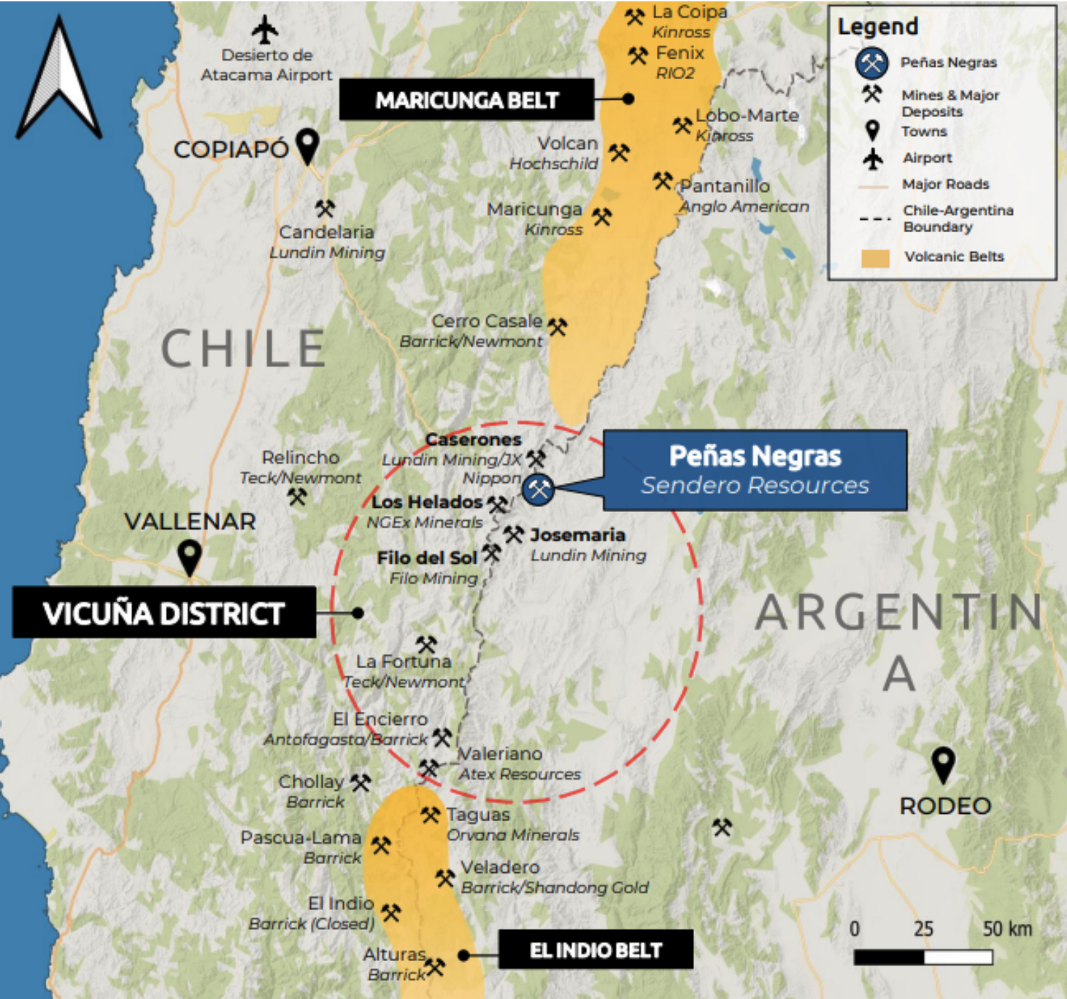
The central Andes region currently contributes a substantial 40% of the world's copper supply. This significant share is largely attributed to the presence of several colossal deposit clusters within the region. Traditionally, the area was thought to be divided into two distinct belts: the Maricunga belt and the El Indio belt, separated by a perceived gap. However, recent explorations have shown there is, in fact, no gap between these two belts. What was once considered a divide has now been established as a continuous magmatic belt stretching from El Indio to Maricunga.
One of the intriguing discoveries in this region is the Vicuna Belt, which has been formally defined by renowned geologists like Sillitoe et al. This belt is a remarkable geological feature, extending over 40 kilometers in a northeast-oriented corridor.
The Vicuna Belt is known for its rich deposits of telescoped porphyry and epithermal ores, with significant sites including Filo Del Sol and Caserones. The presence of these valuable resources within the Vicuna Belt underscores the immense potential of the central Andes as a vital contributor to the global copper supply chain.
Overview
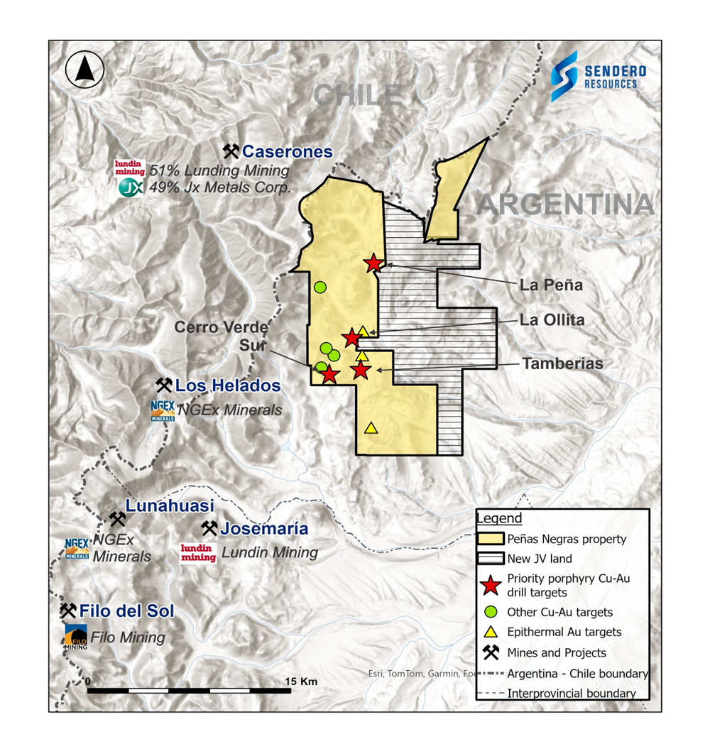
The Peñas Negras property covers an extensive area of 211km2, located within highly prospective regions. It is surrounded by significant, world-class discoveries. Geologically, the property shares similarities with neighboring deposits, particularly the Josemaria copper-gold porphyry system.
The property benefits from excellent access and logistical infrastructure.
Ideal and Strategic Location
Peñas Negras is located close to roads, deep-water ports, skilled labor, and future access to power as nearby mines come into production.
Peñas Negras is strategically located with easy access to essential infrastructure. This includes proximity to well-maintained roads, deep-water ports, a skilled labor force, and the prospect of future power supply as neighboring mining ventures come online. Situated between the industrial hubs of San Juan, Argentina, to the south, and Copiapo, Chile, to the north, the project benefits from its central location. The nearby mining town of Guandacol offers access to skilled miners and a Mining Technician College. Furthermore, there's potential for collaborative infrastructure sharing with neighboring mining projects like Josemaria, Los Helados, and Filo del Sol.
Additionally, the project has access to Caldera, Chile, a deep-water port with direct connections to Asian copper smelters, facilitating the export of copper concentrates. Importantly, the project can apply for benefits under the Argentina-Chile Mining Integration Treaty, allowing for unrestricted movement of people and equipment across the border within a defined "operational area," offering logistical advantages.

Historic Exploration
- Benefiting from more than $8M in Historic Exploration. All available historical exploration data has been compiled into a single property-wide GIS database
- Anglo American, Vale, Golden Arrow, Eldorado, Solitario Resources, and others have spent years exploring the property during the 1990s and 2000s
- Data from these previous explorers include:
- Assay results from 9,430m of Reverse Circulation drilling at La Ollita 3,282m of Diamond Drilling (Cerro Verde areas)
- Assay results for over 6,141 surface samples o 248 km of ground magnetic surveying o 236 km of IP geophysical surveying
- Processed Satellite Alteration (spectral)
La Ollita
Geology
At La Ollita a composite high-sulfidation/porphyry system (telescoped) system has been discovered similar to the other major deposits in the Vicuna District. An advanced argillic lithocap that has been affected by high-sulfidation state mineralization is hosting gold, copper, silver, molybdenum, lead and zinc. A phreatomagmatic breccia with intense pervasive residual vuggy silica and clays with alunite with pyrite-enargite-chalcocite and black sulfide veins has been identified within the lithocap.
The lithocap has been affected by porphyry dykes and porphyry related breccia from porphyry bodies buried below, with a telescoping mineralization and advanced argillic alteration overprinting porphyry-style sericite and potassic (K-feldspar-biotite) alteration with A-type quartz veinlets.
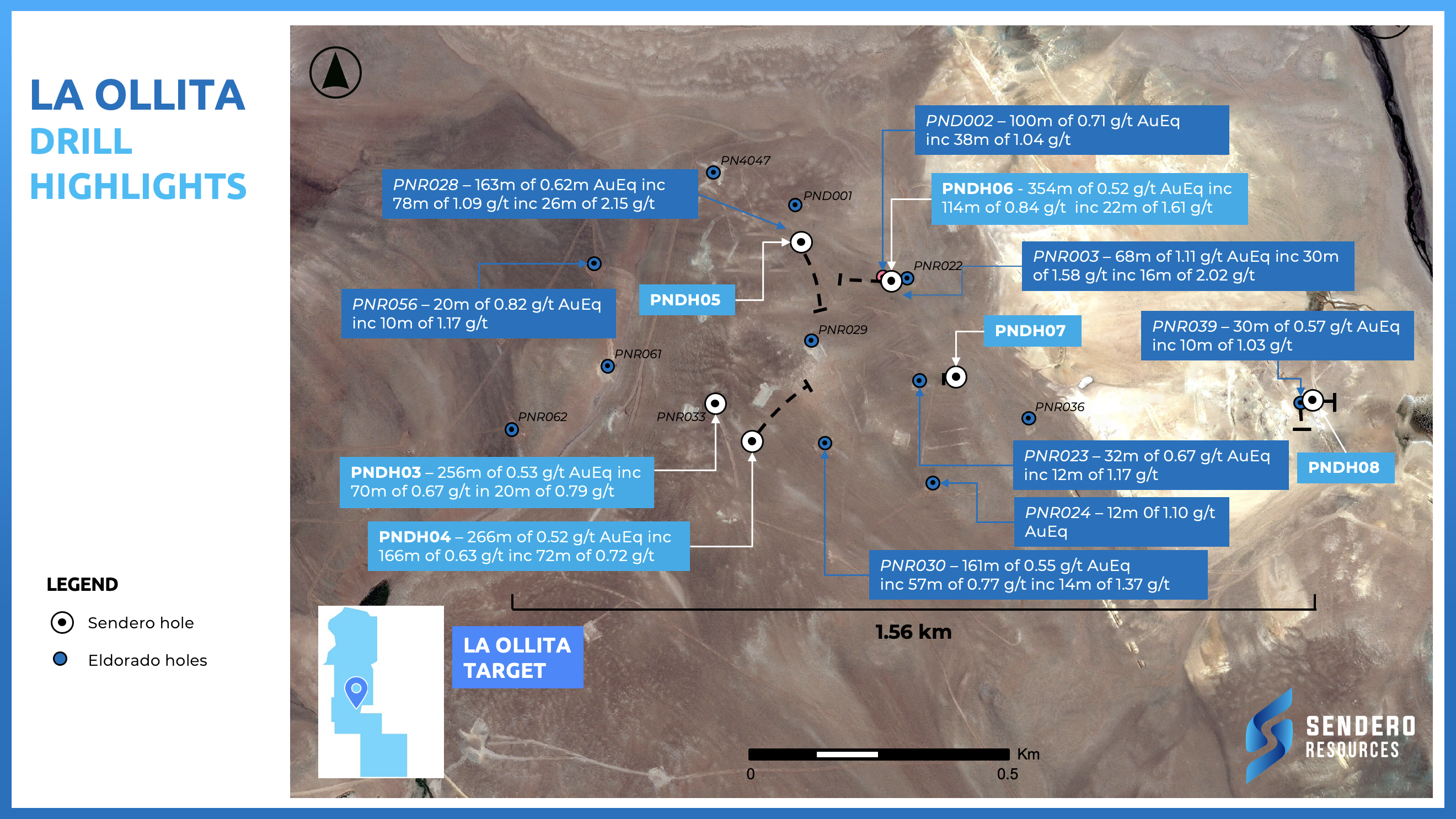
Drill highlights include: 114m of 0.84 g/t AuEq inc 22m of 1.61 g/t AuEq, 68m of 1.11 g/t AuEq inc 16m of 2.02 g/t AuEq and 78m of 1.09 g/t AuEq inc 26m of 2.15 g/t AuEq.
Geophysics
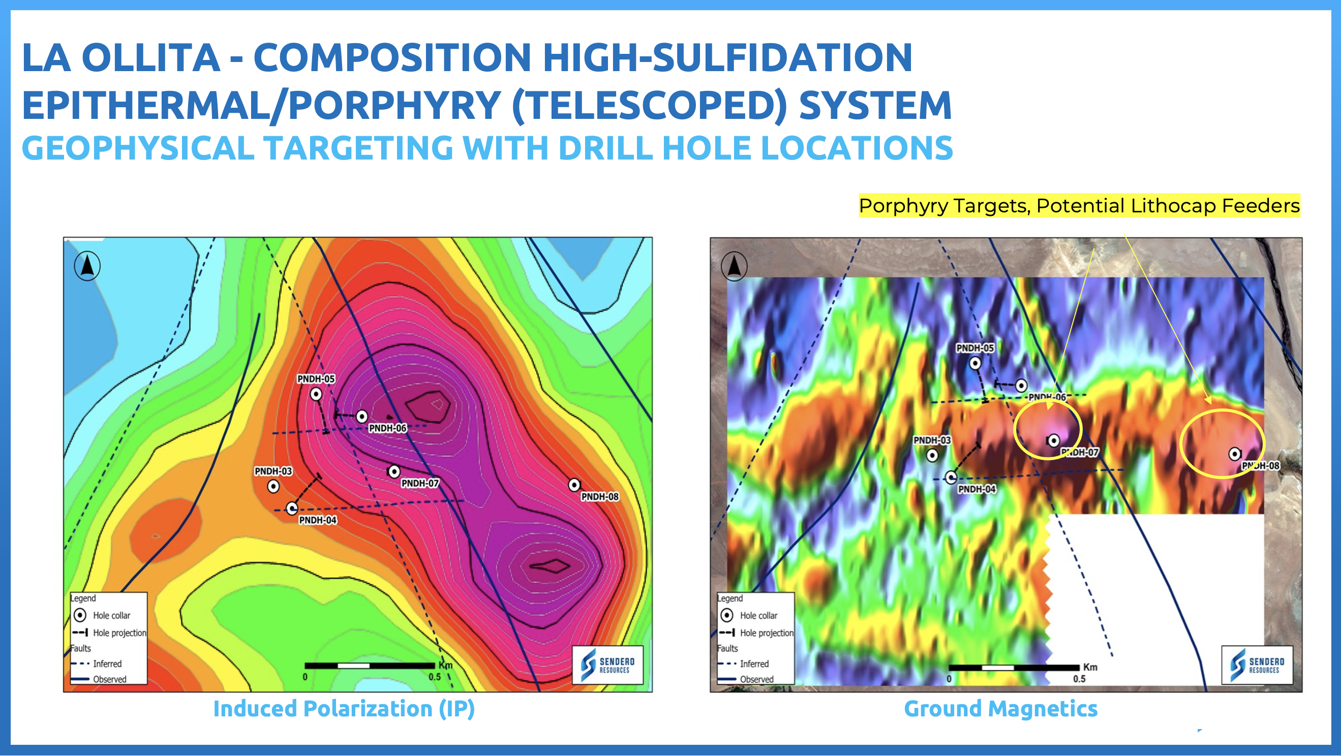
Image Gallery

La Peña
La Peña constitutes a walk-up drill target and has never been drill-tested. Sendero’s Number 1 drill target with all the characteristics of a copper-gold porphyry system
Geology:
The geology of this region features outcropping early Miocene diorite porphyry and breccias, which cut through Permo-Triassic basement rocks consisting of granite and andesite formations. Situated within a NNE structural corridor known as a graben, this area is intersected by a cross-cutting NW fault. Notably, this geological configuration bears a striking resemblance to the structural features observed at Filo del Sol and Josemaria, highlighting the promising geological potential of this location
Mineralization:
The mineralization in this area includes classic porphyry quartz-magnetite vein stockworks, as well as disseminated pyrite and chalcopyrite at the surface, with copper oxides and carbonates.
Alteration:
Well zoned from potassic core to outer green rock (chlorite-epidote) halo
Geochemistry:
Large coincident Cu-Au-Mo geochemical anomaly in talus fines and rock chips centred on the diorite porphyry and quartz vein zone
Geophysics:
A bull’s-eye magnetic anomaly coincides with the central copper-gold anomaly and quartz vein stockwork zone
Maps & Figures
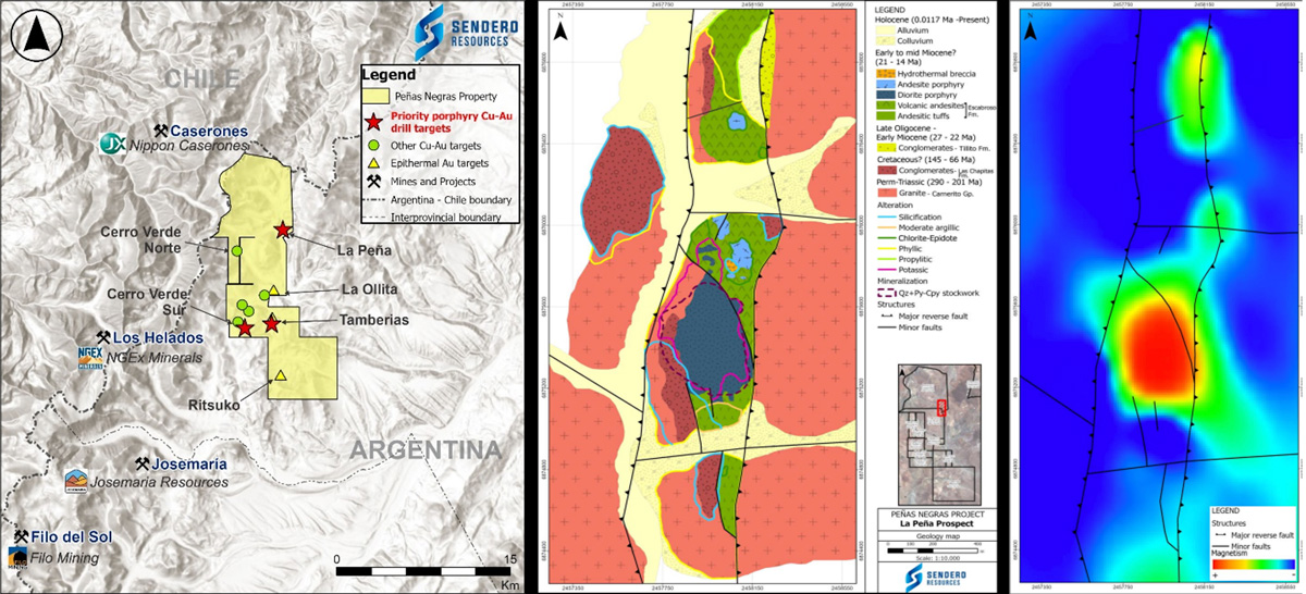
Image Gallery

Tamberias
The Tamberias prospect extends approximately 2km in a NE-SW direction along a structural corridor of the same orientation. The northern section presents an important halo of argillic alteration generating a strong colour anomaly visible from satellite imagery.
Tamberias Central Sector has all the hallmarks of a copper-gold porphyry system with outcropping diorite porphyry
Geology:
The geology consists of Miocene age volcanic rocks intruded by dacitic bodies. These rocks have strong argillic alteration surrounded by chlorite and propylitic alteration. The northern sector has an over imposed silicification highlighting the presence of breccias and quartz veins with anomalous grades of Au and Ag.
Geochemistry:
The rock sampling program reported high exposed Au and Ag grades mainly in the northern (uncovered) sector with values up to 4ppm Au and 98 ppm Ag mostly in quartz veins and breccia. Some Cu anomalies were also reported including 706ppm from a breccia in the north sector and a diorite porphyry with magnetite veinlets showing 440ppm in the central sector. Isolated anomalies of Mo, Zn and Pb are also observed mainly in the northern sector correlating with Au and Ag
Geophysics:
Geophysical surveys further support the evidence of a potential porphyry system in the central zone with a high magnetic anomaly. The interpretation based on the magnetics and radiometric data shows a favourable structural zone for a porphyry emplacement and the presence of what could be a potassic alteration or shallow-level intrusions extending from the Tamberias prospect to the Cerro Verde South prospect.
Maps & Figures:

Image Gallery

Cerro Verde South
Cluster of porphyry targets identified with similar characteristics to other deposits on the Vicuna Belt
Geology:
The host rock at Cerro Verde South is a volcanic unit of Oligocene – Miocene age. The sector hosts an area of advanced argillic and phyllic alteration overprinting silicification. A large dacitic dome dominates the central sector and is coincident with a strong magnetic high. The area shows strong NW-SE trending fault structures intersecting NE-SW faults.
Geochemistry:
Sendero has carried out an extensive talus fine sampling program during the 2021-22 exploration season. The program has identified a 2km long zone with anomalous Cu, Au and Mo. Geochemical anomalies range up to 0.4% copper, 0.84 g/t gold and 10/ g/t silver
Geophysics:
Sendero’s 2022 geophysical survey has identified a large magnetic low coincident with the intersection of structural faulting and anomalous Cu, Au, Mo in geochemistry.
Maps & Figures:
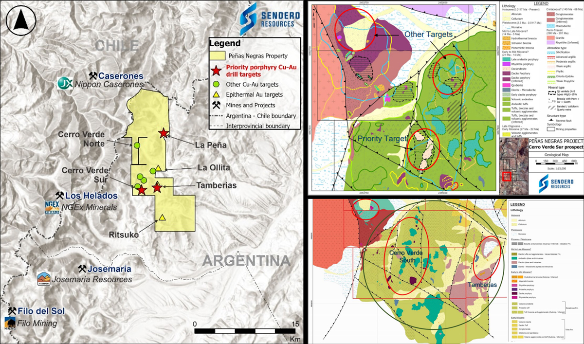
Image Gallery

Cerro Verde North
The Cerro Verde North target comprises an area of advanced argillic alteration encompassing a hydrothermal breccia. These areas are in close proximity to the intersection of NE/NW trending faults which give rise to mineralisation in neighbouring projects. Historical drilling, although shallow (<250m) has proven the presence of mineralisation below a lithocap. The area also has anomalous Au, Cu and Mo in surface samples transitioning to Pb, Zn and Ag at greater distance from the alteration. This evidence, in conjunction with magnetic anomalies, make Cerro Verde North a priority target for Sendero’s 2022 drilling campaign.
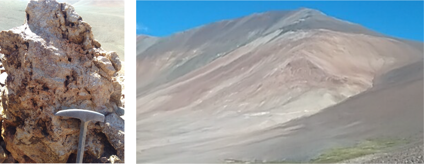
Image Gallery


